


Horton Plains
The park covers an area of 3,160 hectares of montane grassland fringed and interspersed with patches of dense montane cloud forests. This park and the adjoining Peak Wilderness form the most important catchment area for almost all the major rivers in the country. Three major rivers including the longest, Mahaveli (335km), Kelani and Walawe originate from the within the park itself. Kirigalpotta (2,389m) and Thotupalakanda (2,357m) being the second and the third highest mountains in the country respectively are situated within this park. This is also the highest plateau of the country, being above 5,000 feet, and the western slopes of the park support the most extensive area of montane cloud forests surviving in the country. The park comes under the purview of the Department of Wildlife Conservation and a permit is required to enter the park. There are motorable roads as well as footpaths to different locations in the park including the popular "World's End" as referred by locals, which is a vertical drop of 884m, and the picturesque Bakers falls etc. Most of the species of hill birds can be easily seen here during any walk in the park which is through forested areas, grasslands and streams. A walk to the "worlds end" is also through pristine hill bird habitat. There are bungalows as well as camp sites inside the park which have to be pre-booked with the DWLC.
How to get there:-1) Colombo - Avissawella - Hatton - Nanuoya - Ambewela - Pattipola - Horton Plains. 2) Colombo - Ratnapura - Pelmadulla - Balangoda - Haputale - Boralanda - Ohiya - Horton Plains (6 1/2 hours).
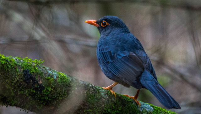
BIRDS: Ceylon Warbler, Ceylon Whistling Thrush, Ceylon Wood Pigeon, Dusky Blue Flycatcher, Scaly Thrush, Spotted-winged Thrush, Ceylon Rufus Babbler, Ceylon Blue Magpie, Ceylon Hill White Eye, Pied Bush Chat, Kashmir Red-Breasted Flycatcher, Common Buzzard Brown Baza, Yellow-Eared Bulbul, Black-Winged Kite, Black Eagle, Mountain Hawk Eagle etc.


